Automatic mapping of high-risk urban areas for Aedes aegypti infestation based on building facade image analysis
Jun 3, 2024· ,,,,,,,,,,,,·
1 min read
,,,,,,,,,,,,·
1 min read
Camila Laranjeira
Matheus Pereira
Raul Oliveira
Gerson Barbosa
Camila Fernandes
Patricia Bermudi
Ester Resende
Eduardo Fernandes
Keiller Nogueira
Valmir Andrade
José Alberto Quintanilha
Jefersson a Dos Santos
Francisco Chiaravalloti-Neto
Abstract
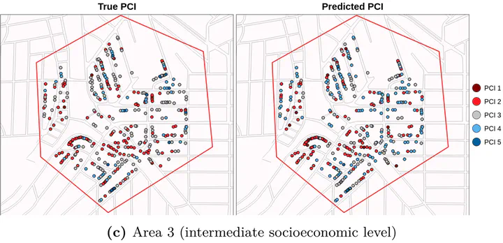
The strategies to control Ae. aegypti require intensive work and considerable financial resources, are time-consuming, and are commonly affected by operational problems requiring urgent improvement. The PCI is a good tool for identifying higher-risk areas; however, its measure requires a high amount of human and material resources, and the aforementioned issues remain. In this paper, we propose a novel approach capable of predicting the PCI of buildings based on street-level images. This first work combines deep learning-based methods with street-level data to predict facade conditions. Considering the good results obtained with PCINet and the good correlations of facade conditions with PCI components, we could use this methodology to classify building conditions without visiting them physically. With this, we intend to overcome the high cost of identifying high-risk areas. Although we have a long road ahead, our results show that PCINet could help to optimize Ae. aegypti and arbovirus surveillance and control, reducing the number of in-person visits necessary to identify buildings or areas at risk.
Type
Publication
In PLOS Neglected Tropical Diseases (2024)
Media coverage
- Analysis of photographs of building facades can help map high-risk urban areas for dengue
- Análise de fotos de fachadas de edifícios pode ajudar a mapear áreas urbanas com alto risco para dengue
- Pesquisadores do DCC aprimoram ferramenta de IA que identifica focos do ‘Aedes aegypti’
- Software desenvolvido pela UFMG utiliza inteligência artificial para identificar focos de dengue
- Pesquisadores da UFMG aprimoram inteligência artificial que identifica focos do Aedes aegypti
- Surto de dengue: cientistas usam IA para identificar focos do “Aedes aegypti”